The Bridges
Before there were bridges at what is now Pacolet Mills, people were crossing the river there. The location was first known as Trough Shoals. A shoal is a shallow place in a river with a rock or gravel bottom. Trough Shoals was surrounded on both sides by exposed rock. There was a channel in the rock that reminded someone of a trough probably like a “hog feeding trough” hence the name was born. Evidently, the name was given to the crossing at an early date. During the Revolutionary War, just before the Battle of Cowpens, Gen. Morgan thought that the British army might cross here. He had guards stationed here to sound the alarm if they did. The British crossed further down the river at Easterwood Ford. Even in 1781, historical accounts use the name Trough Shoals in referring to the crossing.
The first actual bridge was built sometime around 1880. It was a covered wooden bridge and was destroyed in the Great Pacolet Flood of 1903. It was located near where the present concrete bridge is located today. When the bridge was destroyed, a temporary swinging bridge was built and used for awhile. This temporary bridge was replaced by an iron (steel) bridge about 1907. This bridge was used for many years until it was replaced by the present concrete bridge in 1953.
The iron bridge was a short distance upstream from the present bridge. The large, center concrete support for the iron bridge is still standing. Today, there is a statue of a horse, long the symbol of Pacolet, on it.
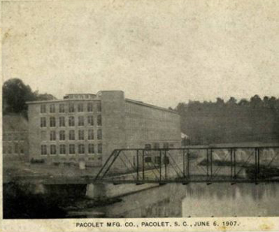
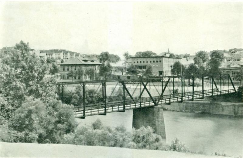
The above photo shows one end of the iron bridge about the time it was built in 1907. The building in the background is Mill No. 5 which was also new at that time. It replaced Mills No. 1 and 2 that were destroyed in the Great Flood of 1903. It is built in their former location.
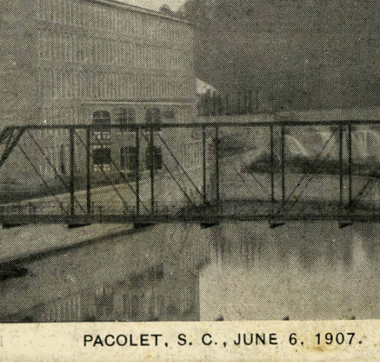
Photo showing the middle part of the iron bridge. The structure built sticking out of Mill No. 5 in the background is the Power House where the large water wheels powering the mill were located. (Thanks to Bruce Norris for placing both of the photos above on the Pacolet Friends group on Facebook.)
There were times before the 1950’s when flood water would almost reach the road bed of the bridge. This was before the large lakes, like Lake Bowen, were built on the upper Pacolet to retain the flood waters. The river in flood was an awesome thing to see- and to hear. Entire grown trees could be seen being carried by the rushing waters.
Crossing the river in flood could be a scary thing for a small child. The walkway for pedestrians was made of wooden planks laid side by side and there were small gaps between them. The raging water did not seem far away when seen through the gaps in the boards. I have heard more than one person talk about having bad dreams as a child about having to cross the river over flood water.
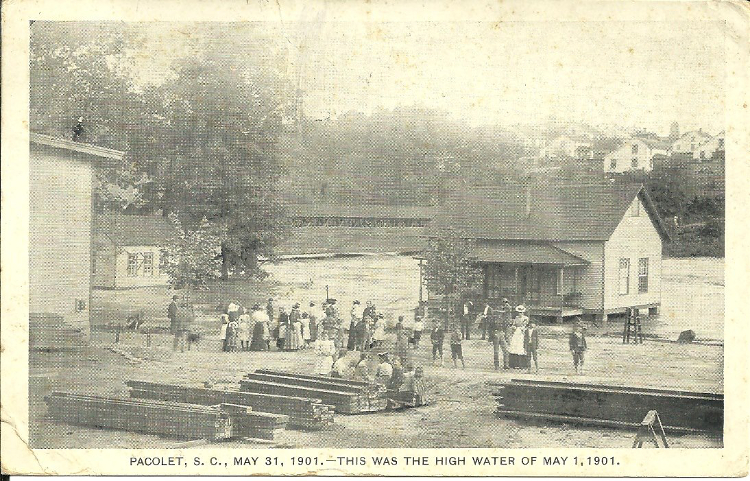
High water was common before the Great Flood of 1903. This rare photo shows very high water only two years before. This picture was taken an area close to "the Flat" and down the hill from the present Town Hall. Note the covered bridge in the background that was destroyed in the flood as well as the houses and structures close to the people in the photo. Notice also the old mill houses on the other side of the river. These were later torn down and replaced by the houses that can still be seen today.
Both ends of the bridge served as a gathering place for men and boys to gather and socialize. There was a railing on the “Flat” side of the bridge that served as a place to sit. On the other end there was a set up steps that led up past Mrs. Sally Gallman’s house that served the same purpose. It was not unusual, day or night, winter or summer, to see men gathered at these places.
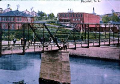
A picture of the bridge taken before 1927.
The iron bridge was very narrow and two cars could barely pass each other on it. If one of the vehicles was a big truck, the oncoming traffic had to wait until it got over. If you crossed in a car or on foot over the old bridge you were very much aware that you were crossing a river.
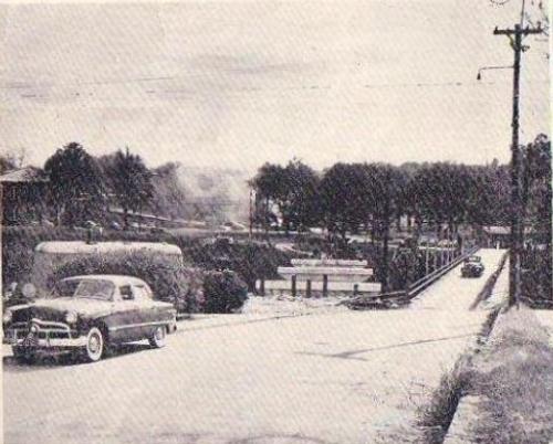
Old bridge is still in use and new bridge is being built.
This all changed when the present concrete bridge was built. The old bridge was kept in use while the new bridge was being built. Upon completion of the new bridge, the old bridge was closed off and eventually torn down.
The new bridge is very wide with pedestrian walkways. When driving, unless you pay close attention, you might not even be aware that you are crossing a once deadly and ferocious river.
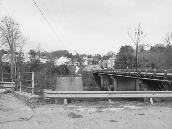
Present concrete bridge and pier from old iron bridge. Note horse statue.
(Photo courtesy South Carolina Department of Archives and History
http://scdah.sc.gov/)
There was a small stream known as Brown's Branch that flowed into the Pacolet River below the Old Mill (Mill No.3). This stream had a narrow bridge on the Gaffney highway that is still probably remembered by many folks, particularly myself. Click on this link to read more about Brown's Branch.
Information and photos have been received about the building of a rail road bridge across the Pacolet River in 1909. Click on this link Rail Road Bridge to read more.

This web site has been started as a public service to share the story of Pacolet.